
Garmin eTrex 22x
4.3Editor score
Sunlight-readable 2.2-inch display
Topo Active maps preloaded
GPS and GLONASS support
Up to 25-hour battery life
A handheld rugged GPS navigator with maps gives hikers, hunters, backpackers, and off-road travelers dependable positioning beyond the coverage and battery limits of a smartphone. The right device combines rugged construction, readable mapping, accurate satellite positioning, useful navigation sensors, and enough battery life to support extended days outdoors.
This guide compares ten navigators across display quality, map resources, satellite support, electronic compass and altimeter functions, storage, water resistance, charging options, and specialized features such as inReach messaging. It includes compact button-operated models, touch-screen units for larger mapping work, and satellite communicators designed for remote travel.
Each pick highlights a different use case, from straightforward topo navigation to advanced expedition planning. Ratings and specifications reflect the supplied product information, while availability and pricing can change. Buyers should confirm current feature details, map coverage, accessory requirements, and subscription conditions before making a final selection.
4.3Editor score

4.3Editor score

3.9Editor score
As an Amazon Associate we earn from qualifying purchases.
The comparison covers screen design, mapping, positioning systems, navigation sensors, durability, power options, and remote communication features, making it easier to match each navigator to a specific outdoor workflow.





The Garmin eTrex 22x combines a familiar handheld form with the core mapping features most hikers and casual outdoor users need. It carries a 4.3 rating and stands out for its sunlight-readable 2.2-inch color display, rugged construction, preloaded Topo Active maps, and support for both GPS and GLONASS satellite systems. Its straightforward design makes it approachable for users who prefer physical buttons over a touchscreen.
We may earn a commission when you buy through this link, at no additional cost to you.
The bundled Topo Active maps include routable roads and trails for activities such as hiking and cycling, removing the need to begin with a blank device. Eight gigabytes of internal memory provides room for map downloads, while the microSD slot offers a practical path for expanding storage. Support for two satellite systems can improve tracking where a GPS-only receiver faces a more challenging signal environment.
The main limitation is that the eTrex 22x does not include the electronic compass and barometric altimeter found in the eTrex 32x. That means it is less convenient for users who want a standing heading or elevation readings without moving. The small screen also provides less visual context than the larger touch-screen alternatives, although it remains well suited to following a trail or checking a nearby waypoint.
This is a strong recommendation for a budget-conscious buyer who wants reliable, map-capable navigation without advanced sensors. It works particularly well for day hikes, local trail exploration, and straightforward travel where replaceable AA batteries are preferred. For users requiring directional and elevation data, the eTrex 32x offers a logical step up.
Preloaded routable topo maps and expandable storage make the eTrex 22x easy to tailor to different trips. Its 240 by 320 color screen is modest, but its sunlight readability supports practical navigation outdoors.
GPS and GLONASS support provide useful redundancy, while the stated runtime of up to 25 hours in GPS mode suits extended days in the field. Two AA batteries make power management straightforward.
We may earn a commission when you buy through this link, at no additional cost to you.
This compact handheld GPS is built for hikers who want a larger map view, physical controls, and broad satellite compatibility in one relatively traditional package. Its 3.9 rating reflects a solid feature set, including a 3.2-inch sunlight-readable screen, IP66 water resistance, and support for GPS, Galileo, BeiDou, and QZSS. The inclusion of a compass and barometric altimeter makes it more capable than the basic eTrex 22x.
We may earn a commission when you buy through this link, at no additional cost to you.
The four-system GNSS support is designed to improve positional accuracy and tracking in challenging environments. Listed positional precision reaches six feet, while the electronic compass maintains a useful heading when the user is stationary. The barometric altimeter adds elevation information, and the device can capture trips and waypoints to help guide users back toward a starting point.
USA topographic maps are preloaded, and 32 GB of internal memory leaves considerable room for additional map downloads. The rechargeable battery is stated to last up to 36 hours at a full charge and uses a standard USB-C cable, eliminating the need for disposable batteries on shorter trips. The IP66 rating offers protection against dust and powerful water jets, although it is not identical to deeper immersion protection.
The device is a compelling option for users who want a larger screen and richer sensors without moving to a full touch-screen unit. Its broad satellite support and rechargeable design are particularly attractive for hikers, campers, and search-and-location use. Buyers who need the strongest water rating or the most established mapping ecosystem may prefer a higher-rated Garmin alternative.
Support for GPS, Galileo, BeiDou, and QZSS gives the navigator access to multiple global positioning systems. That breadth can be useful around dense terrain and other places where satellite visibility varies.
A three-axis compass and barometric altimeter add information that a basic coordinate tracker cannot provide. They are especially useful for maintaining orientation, checking elevation, and navigating when standing still.
We may earn a commission when you buy through this link, at no additional cost to you.
The Garmin eTrex 32x is a balanced, traditional handheld GPS that adds navigational sensors to the feature set of the eTrex 22x. It has a 4.2 rating and is suited to hikers who want more information than a basic tracker without moving to a large touch-screen model. The three-axis compass and barometric altimeter are its clearest advantages over the entry-level eTrex.
We may earn a commission when you buy through this link, at no additional cost to you.
Its 2.2-inch sunlight-readable color display has a 240 by 320 resolution and is paired with preloaded Topo Active maps. Those maps include routable roads and trails for hiking and cycling. GPS and GLONASS support broaden satellite reception, and eight gigabytes of internal memory plus a microSD card slot gives users room for additional map files.
Its compact body and two-AA-battery design prioritize simplicity and endurance. The stated runtime is up to 25 hours in GPS mode, which is practical for ordinary multiday trips, and users can carry spare batteries rather than depend on a proprietary charging setup. The trade-off is the modest screen, which offers less room to inspect surrounding terrain or a complex route than modern touch-screen units.
For trail users who want a compass, altimeter, expandable maps, and dependable physical controls, the eTrex 32x remains an excellent all-around choice. It is less appropriate for users who need a large visual map display, extensive onboard memory, or wireless connectivity. Within the Garmin eTrex line, it provides a clear functional step above the 22x.
The three-axis electronic compass helps users maintain a heading even when stationary, while the barometric altimeter reports elevation. Both features make the device more useful for route-following and terrain awareness.
Physical buttons remain easy to operate in demanding conditions, and the microSD slot expands map storage. Preloaded routable maps make the unit ready for a broad range of hiking and cycling trips.
We may earn a commission when you buy through this link, at no additional cost to you.
The Garmin eTrex Touch represents a modern approach to the rugged eTrex platform, combining a compact body, a 3-inch high-resolution color touchscreen, and advanced positioning support. Its 3.9 rating does not lead the group, but the feature set is among the most sophisticated here. Multi-band GPS, detailed topographic maps, popularity routing, and ascent planning make it particularly relevant for serious trail users.
We may earn a commission when you buy through this link, at no additional cost to you.
The preloaded maps show terrain contours, elevations, summits, parks, coastlines, rivers, lakes, geographic points, and numerous points of interest. Users can swipe and zoom through routes, create round trips based on a desired distance, and review upcoming climbs. An integrated Spine Mount 2 provides mounting support, while compatibility with the Garmin Explore app assists with planning and organizing waypoints, courses, and activities.
This model also addresses power demands with a rechargeable USB-C battery. Under typical use with SatIQ technology, the stated battery life reaches up to 130 hours across all satellite systems and multi-band mode, while expedition mode can extend it to as much as 650 hours. Its IP67 rating supports use in rugged, wet conditions, although the touch interface still deserves care when operated with wet or heavily gloved hands.
The Touch is best suited to hikers who value advanced positioning, rich maps, and touch-screen convenience in a relatively compact package. It is less appropriate for buyers whose priority is the lowest purchase cost or the familiar tactile operation of physical buttons. Optional Outdoor Maps+ content is sold separately, so the included map library should be checked against the intended destination.
Multi-band GPS support is designed to provide optimal positional accuracy. Combined with the eTrex Touch display and sensors, it offers a strong mix of visibility and navigational confidence.
Popularity routing, round-trip suggestions, and ascent planning go beyond simple point-to-point navigation. These functions help hikers understand route difficulty and choose a more suitable path before departure.
We may earn a commission when you buy through this link, at no additional cost to you.
The S190 Handheld GPS combines a 3.2-inch sunlight-readable color display with 64 GB of internal memory, making it one of the strongest storage-focused choices in this roundup. Its 5.0 rating is the highest supplied rating, although ratings alone do not capture every practical limitation. The device supports hiking and camping with preloaded USA topographic maps and a worldwide basemap.
We may earn a commission when you buy through this link, at no additional cost to you.
GPS, BeiDou, Galileo, and QZSS support broaden its satellite capabilities. A three-axis compass displays a heading while the user is stationary, and the unit can record an exact route to guide travelers back along the same path. These features make it useful for hikers, campers, and anyone who wants traceable journeys rather than only isolated coordinates.
The important caveat concerns map detail. The supplied information states that the map may appear blank when zoomed in further because the preloaded state map uses a limited zoom tier. More detailed files can be downloaded using instructions in the product video and manual. Buyers should therefore consider both the generous storage and the time required to load the appropriate regional map before a trip.
With 36 hours of stated battery life and IP64 protection against splashes and outdoor elements, the S190 is a capable option for users who prioritize screen size and storage. It is less ideal for activities requiring more severe water exposure or for people who want every detail included immediately out of the box.
Sixty-four gigabytes provides ample room for regional topo files and downloaded content. It is particularly useful for travelers who visit multiple areas and want detailed maps available without constant connectivity.
Recording an exact journey and guiding the user back along the same path is a valuable safety and convenience feature. The three-axis compass adds useful orientation even when movement no longer changes the displayed heading.
We may earn a commission when you buy through this link, at no additional cost to you.
The Garmin eTrex 10 delivers a straightforward worldwide handheld GPS in a traditional, durable format. It carries a 4.3 rating and distinguishes itself with a preloaded worldwide basemap, WAAS-enabled GPS, HotFix, and GLONASS support. The 2.2-inch monochrome display is less detailed than the color screens elsewhere, but it remains readable and effective for basic route and coordinate work.
We may earn a commission when you buy through this link, at no additional cost to you.
IPX7 waterproofing protects the unit from splashes, rain, and immersion conditions covered by the standard. Paperless geocaching support adds value for users who record and revisit cache locations, while track and waypoint functions can store points such as start, finish, high elevation, and low elevation locations for distance and time estimates.
Two AA batteries provide up to 20 hours of use, making routine power planning easy. The stated runtime is shorter than that of the eTrex 22x and eTrex 32x, and the monochrome display cannot show the same density of map detail as color or touchscreen models. The unit also lacks the newer sensors and wireless features seen in more advanced devices.
The eTrex 10 is a sensible choice for budget-minded travelers, geocachers, and occasional hikers who primarily need reliable global positioning. It works especially well for simple navigation where a full-color topographic display is unnecessary. Users navigating detailed terrain or requiring a compass and altimeter should consider a newer eTrex model.
The preloaded worldwide basemap reduces setup requirements for international travel. It gives users a broad geographic reference even when detailed regional mapping is not required.
The device focuses on dependable positioning, waypoint storage, and track-related calculations. Its uncomplicated feature set makes it approachable for users who do not need advanced touch-screen navigation.
We may earn a commission when you buy through this link, at no additional cost to you.
The Garmin Montana 710 is the most versatile large-screen navigator in the group, earning a 4.3 rating and the Editor's Choice distinction. Its 5-inch glove-friendly touchscreen provides enough room to inspect terrain, trace routes, and review detailed surroundings, while a rugged housing is rated to MIL-STD 810 for thermal, shock, and vibration conditions and IPX7 for water resistance.
We may earn a commission when you buy through this link, at no additional cost to you.
TopoActive maps are included, while additional city and marine mapping options can be downloaded separately. Thirty-two gigabytes of internal memory creates room for further content. Downloadable high-resolution satellite imagery offers an overhead visual reference, and users can establish waypoints based on recognizable landmarks, which is valuable when trail names are sparse or terrain orientation is difficult.
Built-in ABC sensors provide an altimeter, barometer, and three-axis electronic compass. The rechargeable lithium-ion battery offers up to 24 hours in GPS mode and as much as 432 hours in expedition mode, while AA batteries can also be used. USB-C recharging simplifies routine power management. The Garmin Explore app supports planning and review, and active weather forecasts are available through Garmin Connect on a compatible phone.
This is the strongest general-purpose choice for hikers, backpackers, and expedition users who want a large display without adding satellite communications. It is less suitable for ultralight travelers seeking a pocket-sized unit, and optional maps or subscriptions may add cost. Those trade-offs are balanced by the excellent combination of display area, sensors, storage, and rugged construction.
The five-inch color touchscreen makes topographic lines, routes, satellite imagery, and nearby points of interest easier to interpret. Glove-friendly operation also improves usability during active outdoor use.
MIL-STD 810 construction and IPX7 water resistance suit trips exposed to impact, temperature variation, vibration, and rain. The large body is clearly designed as a mounted expedition tool rather than a minimal pocket device.
We may earn a commission when you buy through this link, at no additional cost to you.
The Garmin eTrex SE is an endurance-focused navigator that pairs a familiar 2.2-inch sunlight-readable display with exceptionally long battery options. Its 4.2 rating reflects a well-rounded feature set, including multi-GNSS support across GPS, GLONASS, Galileo, BeiDou, and QZSS, a digital compass, and an IPX7 water-resistant body.
We may earn a commission when you buy through this link, at no additional cost to you.
The standout specification is battery life. Two field-replaceable AA batteries can provide up to 168 hours in standard mode and as much as 1,800 hours in expedition mode. That makes the eTrex SE particularly attractive for long expeditions, extended hunting seasons, and users who prefer to carry spare batteries rather than recharge frequently.
When paired with a compatible smartphone, the Garmin Explore app supports wireless software updates, trip planning, Active Weather, smart notifications, and additional mapping. Automatic Geocaching Live updates can bring in cache descriptions, logs, and hints. These conveniences broaden the unit's usefulness, but the mobile connection remains an important part of accessing the full feature set.
The eTrex SE is a good fit for traditional handheld users who place endurance and broad satellite compatibility above a large touch interface. Its modest screen may disappoint buyers who want detailed route visualization. Even so, the combination of replaceable batteries, a long-running expedition mode, and modern app connectivity gives it unusual versatility for a compact GPS.
The standard and expedition runtime figures allow users to plan around very different trip lengths. Field-replaceable AA batteries add resilience when charging opportunities are limited.
Explore app compatibility brings trip planning, updates, weather information, and notifications into the traditional handheld workflow. Geocaching Live adds another layer of practical outdoor information.
We may earn a commission when you buy through this link, at no additional cost to you.
The Garmin GPSMAP 67i combines rugged handheld mapping with Iridium-based satellite communication, making it a strong choice for travelers who venture beyond reliable cellular coverage. It has a 4.6 rating, the second-highest supplied score in the guide, and a 3-inch sunlight-readable color display. Preloaded TopoActive maps, satellite imagery, multi-band GNSS, and navigation sensors support ordinary outdoor navigation.
We may earn a commission when you buy through this link, at no additional cost to you.
Its defining feature is the inReach platform, which supports two-way messaging, location tracking, and interactive SOS through the global Iridium satellite network. A compatible active subscription is required, and the supplied information notes that some jurisdictions regulate or prohibit satellite communication devices. Buyers must understand those obligations before relying on the feature during a trip.
Paired with a compatible smartphone, the navigator can provide active weather forecasts and Geocaching Live access. The Garmin Explore website and app assist with trip planning, and an optional Outdoor Maps+ subscription delivers premium mapping content over Wi-Fi. The rechargeable lithium-ion battery provides up to 165 hours in ten-minute tracking mode and as much as 425 hours in expedition mode with 30-minute tracking intervals.
This renewed GPSMAP 67i is best for hikers, backcountry travelers, and overlanders who need emergency communication rather than only a conventional GPS. It is less appropriate for casual users who have no need for satellite service and do not want an ongoing subscription. The renewed designation should also be considered alongside the availability of warranty and condition options.
Iridium-based two-way messaging and location sharing extend communication into areas without cellular service. The feature adds meaningful preparedness for remote routes, subject to subscription and legal requirements.
Interactive SOS connects users with a staffed emergency response coordination center. It is a serious safety tool, but it should be treated as part of a broader emergency plan rather than a substitute for judgment, preparation, and local guidance.
We may earn a commission when you buy through this link, at no additional cost to you.
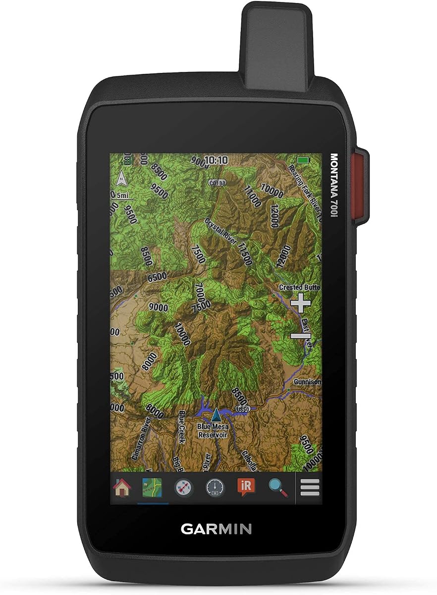
The Garmin Montana 700i is a large-screen rugged navigator with built-in inReach satellite technology, combining detailed local navigation with remote communication features. It carries a 4.0 rating. The 5-inch glove-friendly color touchscreen is 50 percent larger than the display of the previous model, improving route visibility and making the device suitable for mapping work in the field.
We may earn a commission when you buy through this link, at no additional cost to you.
TopoActive maps and City Navigator street mapping are preloaded, while GPS and Galileo provide multi-GNSS positioning. A three-axis compass and barometric altimeter add direction and elevation data. The built-in Iridium network supports two-way messaging and interactive SOS through a staffed monitoring center, provided that an active satellite subscription is in place and applicable local regulations are observed.
Connectivity is unusually broad for a handheld navigator. ANT+ supports compatible sensors, Wi-Fi provides direct access to BirdsEye Satellite Imagery downloads, and Bluetooth enables additional wireless functions. Users can also manage waypoints, routes, activities, collections, tracks, and trip data through the Garmin Explore website or app. These features make the Montana 700i well suited to multi-day trips and users who plan extensively before departure.
The device is a compelling premium-style option for hikers, hunters, and expedition travelers who want a large display and satellite communication in one unit. It is less suitable for casual walks, ultralight travel, or buyers unwilling to maintain a satellite subscription. Because this model is renewed, buyers should review its stated condition, included accessories, and warranty details carefully.
The five-inch glove-friendly display supports detailed route review, while built-in Iridium communication adds a layer of remote safety. Together they serve users who need both local map detail and long-range connectivity.
ANT+, Wi-Fi, Bluetooth, BirdsEye Satellite Imagery downloads, and Garmin Explore support create a flexible planning and sensor ecosystem. It is especially appealing to users who want the handheld to connect with a broader set of outdoor tools.
We may earn a commission when you buy through this link, at no additional cost to you.
The right navigator depends on route complexity, environmental exposure, available power, and whether remote communication matters more than compact size or long battery life.
Display size determines how much surrounding terrain and route detail can be viewed at once. A 2.2-inch screen favors compact, button-operated devices that are easy to carry and operate with gloves, while a 3.2-inch screen provides more map context without becoming tablet-sized. The 5-inch displays on the Montana models are best for route review, satellite imagery, and users who prefer a glove-friendly touch interface. Touchscreens improve zooming and panning but may be less practical with extremely cold hands, wet fingers, or heavy gloves.
A useful handheld must include the appropriate maps for the intended region, not merely a basemap. TopoActive and state topographic downloads support trail navigation, while worldwide basemaps are helpful for broad international travel. City Navigator maps add street-level guidance, and BlueChart g3 charts serve marine use. Some units can receive additional files through microSD cards or internal storage, whereas others require Wi-Fi downloads or a premium map subscription.
Multi-GNSS support combines signals from systems such as GPS, GLONASS, Galileo, BeiDou, and QZSS, which can improve availability in challenging terrain. Multi-band GPS goes further by using multiple frequency bands, offering another layer of positional precision. A device with several satellite systems does not guarantee identical results everywhere, but it generally provides more positioning options than a GPS-only unit.
A three-axis electronic compass provides a heading even while standing still, making it more useful than a basic coordinate display for trail navigation. A barometric altimeter indicates elevation and can support ascent and descent awareness. The Montana 710 also includes a barometer, while the GPSMAP 67i and Montana 700i use broader navigation sensor suites. These tools are valuable in mountainous, wooded, or low-visibility terrain.
Battery expectations should be based on the intended mode. Standard GPS use, continuous tracking, and low-power expedition mode produce very different runtimes. The eTrex SE and eTrex Touch lead in endurance, while the Compact Multi-GNSS GPS and S190 offer stated 36-hour runtimes. Rechargeable USB-C models simplify routine charging, whereas AA battery models allow users to carry spares. Buyers should also account for the loss of battery life in cold weather.
Rugged outdoor use exposes devices to rain, dust, impact, vibration, and temperature changes. IPX7, IP66, and IP64 indicate different levels of protection against water, while MIL-STD 810 testing covers conditions such as thermal exposure, shock, and vibration. A higher rating is valuable for boating, severe weather, and trips where the navigator cannot be replaced easily. Physical button models can also be easier to operate when a touchscreen is less responsive.
Internal storage determines how many detailed map regions can be carried offline. The S190 provides 64 GB, the Garmin Montana 710 provides 32 GB, and smaller eTrex models use 8 GB or a microSD card. Bluetooth, Wi-Fi, ANT+, and Garmin app compatibility can simplify updates, trip planning, weather access, geocaching information, and sensor pairing. These conveniences are valuable, although some features still require a compatible smartphone.
The GPSMAP 67i and Montana 700i add Iridium-based two-way messaging, location sharing, and interactive SOS. These capabilities can be important for remote travel, but they require an active subscription, and some jurisdictions regulate or prohibit satellite communication devices. Units without communications remain dependable standalone navigation tools but do not provide a way to contact emergency services when cellular service is absent.
Before leaving home, charge the device fully, install fresh batteries if it uses removable cells, and confirm that the correct regional maps are stored on the device. Explore the primary menu, create a waypoint at the trailhead, record a short test track, and confirm that the compass heading changes as the unit is turned. Users should also pair the navigator with the appropriate app if they intend to use weather, geocaching, route management, or software updates.
On the trail, treat the navigator as an aid to navigation rather than the sole source of direction. Compare its position and route with a paper map, trail signs, and local information. Start a track before traveling, keep the screen within its stated operating conditions, and use physical buttons when gloves make touch operation difficult. Satellite communicators should be tested before remote travel, with messages and emergency information kept concise.
After the trip, remove the batteries from models that use them, clean dirt and moisture from the housing, and keep the device away from direct heat while it dries. Protect the screen from abrasion and use suitable mounts or cases for storage. Download any required map or software updates at home, and check the battery condition regularly if the unit uses rechargeable power.
A dedicated handheld often lasts longer, tolerates harsh conditions better, and continues providing maps and positioning where a phone's battery or screen may fail. A smartphone can still be valuable for photography, downloaded apps, and route communication. The ideal setup depends on the trip, but a dedicated navigator is a strong choice for remote or extended outdoor travel.
Multi-GNSS means the receiver can use signals from multiple global navigation satellite systems, such as GPS, GLONASS, Galileo, BeiDou, and QZSS. Access to additional systems can improve positioning when terrain, vegetation, or the horizon makes some satellites less visible. Multi-band GPS goes a step further by using multiple frequency bands for potentially greater precision.
A compass is highly useful because it can show direction while standing still, while an altimeter provides elevation information and supports terrain awareness. Neither is essential for every casual outing, but both add confidence on trails with confusing junctions, significant elevation changes, or poor visibility. Models such as the eTrex 32x include both.
Most models in this guide support some form of downloadable mapping, but the method depends on the device. Options include microSD cards, internal storage, computer downloads, or Wi-Fi transfer, and premium content may require a subscription. Users should download and verify detailed maps before leaving an area with dependable connectivity.
Yes. The inReach functions in the GPSMAP 67i and Montana 700i use the global Iridium satellite network for messaging, tracking, and SOS functions, so cellular coverage is not required. An active subscription is necessary, and local rules regarding satellite communication devices should be checked before use.
Rechargeable models are convenient for trips with regular charging opportunities, while AA-powered devices can be more resilient when spare batteries are easy to carry. The eTrex SE offers especially long stated runtimes, including up to 1,800 hours in expedition mode. Cold weather and heavy screen use can reduce real-world runtime, so carrying a backup power plan remains sensible.
IPX7 is suited to rain, splashes, and short-term immersion, while IP66 protects against powerful water jets and dust. IP64 is primarily a splash-resistance rating and is less protective during heavy rain or accidental submersion. Buyers should match the rating to the activity, and avoid charging or operating any device beyond its environmental limits.
A renewed unit can provide the same core navigation and communication functions at a different price point, but its physical condition and warranty may vary. Check the seller description for screen marks, housing wear, included accessories, battery condition, and return terms. The GPSMAP 67i and Montana 700i are the renewed models in this guide, so close inspection is particularly important.
The Garmin eTrex 22x is the balanced budget selection, while the Garmin Montana 710 stands out as the most capable general-purpose navigator in the roundup. The Garmin eTrex Touch earns the premium designation through multi-band positioning, detailed maps, modern touch controls, and exceptional battery options. Each serves a distinct need rather than simply duplicating the others.
The right priority depends on the trip. Choose a small button-operated eTrex for simple navigation and replaceable batteries, a larger touchscreen for terrain review, or an inReach model when remote communication and emergency support are essential. Map coverage, sensor availability, water resistance, and expected battery mode should be evaluated before screen size alone.
Current prices and availability change, so buyers should verify the latest listing, included accessories, map conditions, warranty details, and any subscription requirements at the time of purchase. Those checks ensure that the selected navigator remains suitable for the intended route and that its ongoing costs are understood.